 ICEYE Hurricane Solution Source: ICEYE Oy
Rapid Geospatial Insight for Hurricane Events
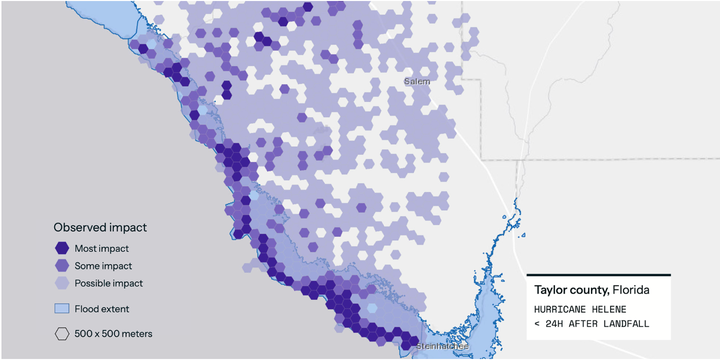
As part of ICEYE’s Hurricane Solution development team, I applied my SAR remote sensing and geospatial science expertise to create the raster-based damage layers and hexgrid products that underpin the Rapid Impact Heat Map. This product delivers high-resolution, data-driven insights on structural impacts across storm-affected regions within 24 hours of landfall.
Using ICEYE’s persistent SAR constellation, we monitored hurricane paths in near-real-time, generating geospatial raster outputs that highlight the extent and severity of wind damage. I was responsible for crafting the change detection workflows and post-processing pipelines that translate raw SAR data into actionable insights for insurers and emergency responders.
My Contributions:
- Remote Sensing Expertise:
- Engineered end-to-end processing chains for X-band SAR imagery to detect structural changes across urban and rural landscapes
- Tuned raster product generation to achieve consistent, high-accuracy impact footprints for rapid claims triage and risk segmentation
- Geospatial Science: Developed hexgrid-based damage summaries to support rapid exposure quantification and visual interpretation at multiple spatial scales
- Stakeholder Communication: Collaborated with product and engineering teams to operationalize workflows under tight disaster response timelines
Solution Highlights:
- Combined view of wind-related damage derived from multi-temporal SAR observations, offered at 30 m resolution.
- Always-on, all-weather monitoring with ICEYE’s SAR satellites, ensuring uninterrupted damage intelligence even through clouds and darkness.
- Hexgrid-based visualizations to simplify decision-making and resource allocation in disaster zones.
- Rapid delivery of actionable geospatial layers compatible with industry-standard GIS tools and APIs.
ICEYE’s Hurricane Solution enables insurers to identify affected assets, estimate exposure, and deploy adjusters efficiently—before traditional aerial or optical data becomes available.
Additional Resources:
Udit Asopa
Remote Sensing Data Specialist (official title: SAR Remote Sensing Engineer)
I specialize in SAR and GIS-based Earth observation workflows for environmental monitoring, disaster response, and scientific analysis. With a focus on automation, reproducibility, and applied geospatial intelligence, I contribute to building scalable, data-driven solutions.