 ICEYE Wildfire Product Source: ICEYE Oy
Rapid Structural Damage Mapping During Wildfire Events
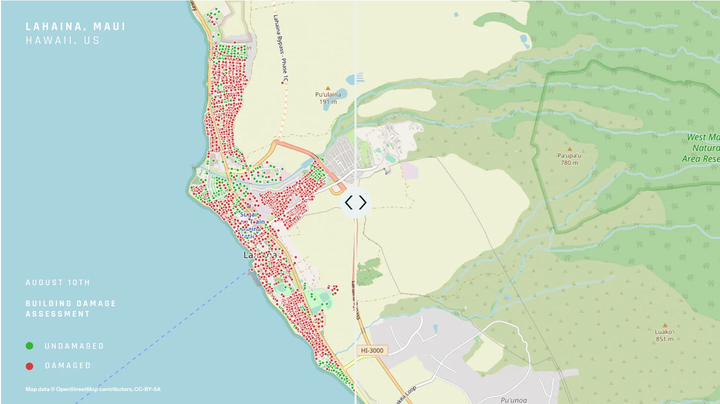
At ICEYE, I helped advance the Wildfire Insights solution by applying SAR remote sensing and geospatial science expertise to develop building-level damage detection tools. This solution supports insurers with verified damage data within 24 hours of wildfire impact—independent of weather or daylight conditions.
Using ICEYE’s X-band SAR constellation, I worked on SAR-based change detection techniques to identify structural loss across fire-affected zones. My contributions included algorithm tuning for urban infrastructure detection, post-classification processing, and integrating the results with geospatial vector formats for seamless decision support.
My Contributions:
- Remote Sensing Expertise: Built Remote Sensing-based (SAR) workflows for detecting and classifying structural loss in wildfire zones.
- Geospatial Science:
- Helped calibrate damage detection thresholds across diverse terrains and settlement types
- Delivered vector-based outputs (point and polygon layers) for operational insurance workflows.
- Data Analytics & Geospatial Scince: Collaborated on integrating outputs into Esri-based dashboards for real-time situational awareness.
Product Features:
- Building-level binary classification of ‘destroyed’ vs. ‘undamaged’ within hours of fire containment.
- Actionable vector outputs ready for ingestion by GIS teams and insurers.
- ESRI wildfire monitoring dashboard combining SAR results, fire perimeters, hotspots, and urban exposure layers.
- Consistent insights across multiple wildfire events regardless of smoke or cloud cover.
ICEYE’s Wildfire Insights enables insurers and emergency response teams to make timely, data-driven decisions without waiting for aerial or optical validation.
Additional Resources:
Udit Asopa
Remote Sensing Data Specialist (official title: SAR Remote Sensing Engineer)
I specialize in SAR and GIS-based Earth observation workflows for environmental monitoring, disaster response, and scientific analysis. With a focus on automation, reproducibility, and applied geospatial intelligence, I contribute to building scalable, data-driven solutions.